Article
Falklands Maritime Heritage Trust

Underwater Engineer

Nico Vincent helped discover a famous explorer's ship at the bottom of the Southern Ocean.

By Hailee Romain

Learning Objective: Students will use a coordinate grid to plot the path of a drone and the objects it located on the seafloor.

Lexile: 800L; 610L

Esther Horvath/Falklands Maritime Heritage Trust 

Nico Vincent

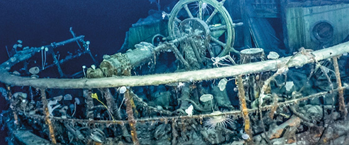
This past March, a team of scientists and archaeologists made an exciting discovery in the waters around Antarctica. They found the wreck of a ship called  Endurance. The ship sank in 1915 after being crushed by sea ice. Led by famous explorer Ernest Shackleton, the Endurance crew made a dangerous journey across the frozen ocean. Amazingly, they all survived. But the lost ship’s exact location remained a mystery for 106 years.

Nico Vincent led the underwater search for the wreck. He’s a subsea engineer and commercial diver. Vincent has spent years searching for shipwrecks. This, he says, was the most challenging search of his career.

This past March, a team of scientists and archaeologists made an exciting discovery. They traveled to Antarctica and searched the waters around it. Eventually, they found the wreck of a ship called Endurance. The ship was crushed by sea ice in 1915. It sank. The Endurance crew had to cross the frozen ocean. They were led by Ernest Shackleton. He was a famous explorer. Amazingly, the entire crew survived the dangerous journey. But the ship was lost. Its exact location remained a mystery for 106 years.

Nico Vincent led the underwater search for the wreck. He’s a subsea engineer and commercial diver. Vincent has spent years searching for shipwrecks. This, he says, was the most challenging search of his career.

Falklands Maritime Heritage Trust 

The ship sank more than 100 years ago. Its location was unknown until now.

The Search 

Esther Horvath/Falklands Maritime Heritage Trust 

This underwater drone scanned the seafloor and detected the Endurance.

First, Vincent and his team created a search grid. They released a pair of underwater drones. The drones steered themselves along a path over the grid. They mapped the seafloor using sonar, which relies on sound waves to measure an object’s distance.

The surface of the water was covered in floating sheets of ice roughly 6 feet thick. “We had to engineer our tools from scratch to handle the environment,” Vincent says. To stop the drones from getting lost beneath the ice, a fiber-optic cable kept them tethered to the expedition ship. This connection also allowed a human pilot to take control in an emergency. “We had to be prepared for the unexpected,” explains Vincent.

First, Vincent and his team created a search grid. They released a pair of underwater drones. The drones steered themselves along a path over the grid. They mapped the seafloor using sonar. Sonar uses sound waves to measure an object’s distance.

The surface of the water was covered in floating sheets of ice. Each sheet was roughly 6 feet thick. “We had to engineer our tools from scratch to handle the environment,” Vincent says. A fiber-optic cable kept the drones tethered to Vincent’s ship. This connection stopped the drones from getting lost beneath the ice. It also allowed a human pilot to take control in an emergency. “We had to be prepared for the unexpected,” explains Vincent.

The Find

steeve-x-foto/Alamy Stock Photo

The Endurance attempted to make a dangerous journey across the frozen ocean.

After two weeks of searching, Vincent’s team spotted a ship-shaped object on the sonar images. It was lying on the seafloor, nearly 2 miles below the surface. They sent the drone in for a closer look. What the sonar had shown was the Endurance! The ship had been well-preserved in the cold water.

Vincent’s team took 3-D scans to create a virtual model of the wreck. Now the world can see it.

“I’m proud to be part of Shackleton’s legacy,” he says.

Vincent’s team searched for two weeks. Finally, they spotted an object on the sonar images. It was lying on the seafloor, nearly 2 miles below the surface. It was shaped like a ship. They sent the drone in for a closer look. It was the Endurance! The ship had been well-preserved in the cold water.

Vincent’s team took 3-D scans of their find. They created a virtual model of the wreck. Now the world can see it.

“I’m proud to be part of Shackleton’s legacy,” he says.

Analysis

Answer the following questions on a separate sheet of paper.


Write directions for the drone to travel from point D to point W, with a stop on the way to investigate point A.

Write directions for the drone to travel from point D to point W, with a stop on the way to investigate point A.

To return to the ship, the drone must get from point W to point S. Is it closer for the drone to head south then east or east then south? Explain.

To return to the ship, the drone must get from point W to point S. Is it closer for the drone to head south then east or east then south? Explain.

video (2)
video (2)
Activities (6)
Answer Key (1)
video (2)
video (2)
Activities (6)
Answer Key (1)
Step-by-Step Lesson Plan

1. SPARK ENGAGEMENT.

Play the video "The Search for the Sunken Ship." Then, before or after reading the article, spark a discussion based on the following questions.

  • How can technology be used to help us locate lost items?
  • How would you give someone directions to a place without using the internet or an electronic device? Explain.

2. INTRODUCE THE MATH CONCEPT AND VOCABULARY

  • Display a coordinate grid. (You can use the "Coordinate Grid" template from DynaMath Online). What can you tell me about this image? (Answers will vary.) This is a coordinate grid.
  • What do you notice about the vertical line on the left side of the grid? (It is a number line that starts at 0 and increases by increments of 1.) That is the y-axis. Where do you think the x-axis is located? (It is the horizontal number line across the bottom of the grid.)
  • Draw or place a circle on the grid where two lines intersect. This is called a coordinate point. We write its location by counting the units to the right along the x-axis, then by counting the units up along the y-axis from the origin, or (0,0), until we reach it. What is the location of this point? (Answers will vary.)
  • Play the math video "Coordinate Planes."

3. WORK THROUGH THE "WHAT TO DO" BOX.

  • Do the points (10,8) and (8,10) represent the same location on the coordinate grid? (No. (10,8) is 10 units to the right and 8 units above the origin, while (8,10) is 8 units to the right and 10 units above the origin.)
  • What does the compass rose on page 21 show us? (the directions: north, south, east, west)
  • To move east of a point, do you move to the right or left? (to the right)
  • To move south of a point, do you move up or down? (down)

4. ANALYZE ENDINGS.

  • Have students complete probelsm 1 and 2 on page 21.

Text-to-Speech