Article
ILLUSTRATION BY MAGICTORCH (PLANE ILLUSTRATION); NASA (HURRICANE)

Into the Storm

By Jeanette Ferrara
From the November 2019 Issue

ILLUSTRATION BY MAGICTORCH (PLANE ILLUSTRATION); NASA (HURRICANE)

Along the east coast of the United States, the months of June through November are known as hurricane season. Each year during that time, an average of 10 strong tropical storms and hurricanes barrel across the Atlantic Ocean and the Gulf of Mexico. As the storms make their way toward land, authorities urge residents in their path to leave the area.

At the same time, one group of brave researchers makes a bold move to help keep people safe. They board a plane and fly straight into the heart of the hurricane. “We don’t do it as a thrill ride,” says meteorologist Richard Henning. He’s part of the National Oceanic and Atmospheric Administration’s hurricane hunter team. This group of skilled pilots and scientists fly a plane equipped with high-tech devices. The data they collect can reveal how the storm will likely change—and where it will hit next.

Hurricane season lasts from June to November along the east coast of the United States. About 10 strong storms form each year during that time. The storms barrel across the Atlantic Ocean and the Gulf of Mexico. They sometimes head toward land. Officials warn people in the storms’ path to leave the area.

But one group of brave researchers does the opposite. They hop on a plane. Then they fly into the heart of the storm. They risk their lives to keep people safe. “We don’t do it as a thrill ride,” says Richard Henning. He’s a meteorologist. 

Henning works for the National Oceanic and Atmospheric Administration. He’s part of the hurricane hunter team. It’s a group of skilled pilots and scientists. They fly on a plane with many high-tech devices. They collect data. The data can show how a storm will likely change. And it can show where a storm could hit next.

Inside a Hurricane

Hurricanes are dangerous storms that form over the ocean. As warm air above the water rises, it pulls moisture up with it, forming rain clouds. When the rain falls, it drags cooler, denser air back down to the water’s surface. Repeated over and over, the process creates a swirling storm. 

A hurricane gains speed and strength as it moves across the ocean. When it hits land, it can do major damage. It brings heavy rains that often cause flooding. A Category 5 hurricane has wind speeds of more than 252 kilometers (156 miles) per hour (see How Strong Is the Storm?). That’s strong enough to topple most buildings!

Hurricanes are dangerous storms. They form over the ocean. Warm air above the water rises. It pulls water droplets up with it. That causes rain clouds to form. Then rain falls. It drags cooler, wet air back down to the ocean. This happens over and over again. The process creates a swirling storm. 

A hurricane moves across the ocean. It gains speed and strength. It can do major damage when it hits land. It brings heavy rains. Hurricanes often cause flooding. A Category 5 is the strongest hurricane. It has wind speeds greater than 252 kilometers (156 miles) per hour (see How Strong Is the Storm?). That’s strong enough to topple most buildings!

A hurricane’s most ferocious winds spiral around the storm’s center. This barrier of  superstrong winds is called the eyewall. But at the very middle of the storm, called the eye, the air is completely calm.

Measuring the speed and direction of winds in the eyewall can help scientists predict the hurricane’s path. The best way to collect this data is by flying through the storm. That’s where the hurricane hunters come in.

A hurricane’s strongest winds spin around the storm’s center. They form an eyewall. The air is totally calm in the middle of the storm. This is called the eye.

The speed and direction of winds in the eyewall can help predict a hurricane’s path. That’s where the hurricane hunters come in. They fly through the storm to collect this data. 

Lt. Kevin Doremus/NOAA

Researchers known as hurricane hunters approach Hurricane Harvey in August 2017.

Storm Hunters

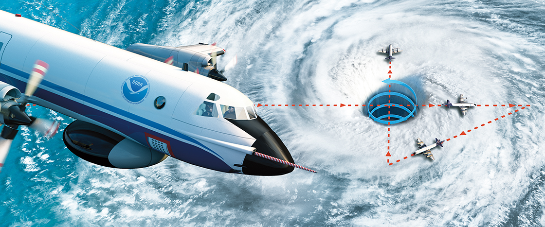
Each hurricane hunter mission includes about 16-18 crew members and scientists. They take off from a base in Lakeland, Florida. Once the plane gets close to the storm, the pilot steers straight for the eye.

Approaching the eye can be a bumpy ride. “It’s like riding a roller coaster for about 10 minutes until you punch into the center of the storm,” says pilot Robert Mitchell. There, the wind slows and the air becomes calm. In strong hurricanes, the sky above the plane is often completely clear.

 The plane crosses through the eye and the eyewall several times. During the flight, radar gives scientists a 3-D view of the storm. The plane’s instruments measure factors such as wind speed and direction. The team also releases devices that measure the temperature and air pressure in the swirling winds.

Each hurricane hunter mission has 16 to 18 crew members. They take off from a base in Lakeland, Florida. Ast the plane nears the storm, the pilot steers right for the eye.

It can be a bumpy ride. “It’s like riding a roller coaster for about 10 minutes,” says pilot Robert Mitchell. “Until you punch into the center of the storm.” There, the wind slows. The air iscalm. The sky above the plane is often totally clear.

The plane crosses through the eye and the eyewall many times. Scientists scan the hurricane with radar. It gives them a 3-D view of the storm. The plane’s instruments measure other things. These include wind speed and direction. The team also releases devices into the swirling winds. The devices measure the temperature and the air pressure. 

Decoding the Data

All that data is sent to the National Hurricane Center in Miami, Florida. Scientists there feed the measurements into a computer that builds a simulation of the storm. This model helps scientists predict how the hurricane will behave.

For instance, some hurricanes change to Category 1 storms to Category 4 in less than 24 hours. Thanks to simulations, scientists now know under what conditions this is likely to happen.

All that data is sent to the National Hurricane Center in Miami, Florida. Scientists there put the data into a computer. The computer builds a simulation of the storm. This model helps scientists learn how the hurricane will act. 

Some hurricanes change strength. For example, a storm can change from a Category 1 to Category 4 in less than 24 hours. Scientists now know when this is likely to happen. That’s thanks to simulations.

CHRIS URSO/TAMPA TRIBUNE/AP PHOTO (SCIENTIST); NOAA VIA GETTY IMAGES (HURRICANE DORIAN)

A scientist prepares a data-collecting instrument to be sent into a hurricane. This satellite image (inset) shows Hurricane Dorian nearing Florida on September 1, 2019.

Pinpointing when and where a storm will likely hit land saves lives. It gives people in the storm’s path time to evacuate. They won’t be trapped when the storm brings dangerously strong winds and floods.

“Nature is still often unpredictable,” says Henning. But thanks to the hurricane hunters, researchers understand these storms better than ever.

Knowing when and where a storm could hit land saves lives. It gives people in the storm’s path time to get away. The storm could bring strong winds and floods. People who leave in time won’t be trapped. 

“Nature is still often unpredictable,” says Henning. But today, researchers understand these storms better than ever. That’s largely because of the work of hurricane hunters.

Chip Somodevilla/Getty Images

Residents in North Carolina escape homes flooded by Hurricane Florence in September 2018.

video (1)
Activities (4) Download Answer Key
Text-to-Speech